Latitude and longitude of Beauregard, Alabama
- Nearby Tuskegee, United States
Satellite map of Beauregard, Alabama
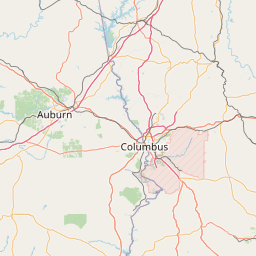
Beauregard is an unincorporated community located in central Lee County, Alabama, United States, east of Auburn and south of Opelika. It is part of the Auburn Metropolitan Area. While Beauregard has been traditionally considered to be a small area near the crossroads of Alabama State Route 51 and Lee County Road 400, today most residents within a roughly 25 square mile (65 km2) area surrounding the original community consider themselves to be in "Beauregard".
Latitude: 32° 32' 20.99" N
Longitude: -85° 22' 8.99" W
Nearest city to this article: Auburn, Alabama
Read about Beauregard, Alabama in the Wikipedia Satellite map of Beauregard, Alabama in Google Maps


Leaflet | © OpenStreetMap contributors