Latitude and longitude of Boston College High School
- Nearby Hull, Massachusetts, United States
Satellite map of Boston College High School
Boston College High School (also known as BC High) is an all-male Jesuit Roman Catholic college preparatory secondary school founded in 1863 with historical ties to Boston College.
Latitude: 42° 18' 34.80" N
Longitude: -71° 02' 28.20" W
Nearest city to this article: Jamaica Plain
Read about Boston College High School in the Wikipedia Satellite map of Boston College High School in Google Maps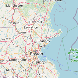


Leaflet | © OpenStreetMap contributors