Latitude and longitude of 1860 Wiyot massacre
- Nearby Fortuna, California, United States
Satellite map of 1860 Wiyot massacre
The Wiyot massacre refers to the incidents on February 26, 1860, at Tuluwat on what is now known as Indian Island, near Eureka in Humboldt County, California. In coordinated attacks beginning at about 6 am more than 80 Wiyot people, mostly women and children, were murdered with axes, knives, and guns. The February 26 attacks were followed by similar bloody attacks on other Wiyot villages later that week.
Latitude: 40° 48' 54.00" N
Longitude: -124° 09' 39.60" W
Nearest city to this article: Eureka, California
Read about 1860 Wiyot massacre in the Wikipedia Satellite map of 1860 Wiyot massacre in Google Maps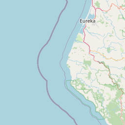


Leaflet | © OpenStreetMap contributors