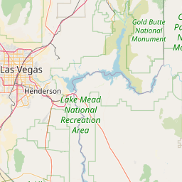
Latitude and longitude of The Harmon
- Nearby Spring Valley, Nevada, United States
Satellite map of The Harmon
The Harmon is a highrise building in the CityCenter Las Vegas development in Paradise, Nevada. The tower was designed by Foster + Partners as a non-gaming boutique hotel, and was to be operated by Andrew Sasson's The Light Group upon completion. The building features an elliptical layout and highly reflective exterior located on the northeast corner of the project at the intersection of Las Vegas Boulevard and Harmon Avenue. Serious construction defects to the building were discovered in 2008, and the project was halted indefinitely. On August 23, 2013, a Clark County court approved the tower's demolition.
Latitude: 36° 06' 18.75" N
Longitude: -115° 10' 15.00" W
Nearest city to this article: Spring Valley, Nevada
Read about The Harmon in the Wikipedia Satellite map of The Harmon in Google Maps