Latitude and longitude of Glendale, Humboldt County, California
- Nearby McKinleyville, United States
Satellite map of Glendale, Humboldt County, California
Glendale (Wiyot: p'lèta-kawèti "rocks-white" ) is an unincorporated community in Humboldt County, California. It is located on the Mad River 4 miles (6 km) east-northeast of Arcata, at an elevation of 92 feet (28 m).
Latitude: 40° 53' 35.39" N
Longitude: -124° 01' 0.60" W
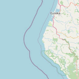


Leaflet | © OpenStreetMap contributors