Latitude and longitude of Arizona Snowbowl
- Nearby Flagstaff, Arizona, United States
Satellite map of Arizona Snowbowl
Arizona Snowbowl is an alpine ski resort located on the San Francisco Peaks, 7 miles (11.2 kilometers) north of Flagstaff, Arizona.
Latitude: 35° 19' 24.00" N
Longitude: -111° 41' 25.79" W
Nearest city to this article: Flagstaff, Arizona
Read about Arizona Snowbowl in the Wikipedia Satellite map of Arizona Snowbowl in Google Maps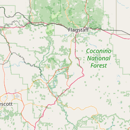

Leaflet | © OpenStreetMap contributors