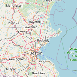
Latitude and longitude of New Boston Air Force Station
- Nearby Sandown, New Hampshire, United States
Satellite map of New Boston Air Force Station
New Boston Air Force Station is a United States Air Force facility located in Hillsborough County in south central New Hampshire. It occupies more than 2,800 acres (11 km²) in three towns: New Boston, Amherst, and Mont Vernon. It was established in 1942 as a practice area for bombers and fighter planes from nearby Grenier Army Air Field (now Manchester-Boston Regional Airport).
Latitude: 42° 56' 32.46" N
Longitude: -71° 38' 9.94" W
Nearest city to this article: New Boston, New Hampshire
Read about New Boston Air Force Station in the Wikipedia Satellite map of New Boston Air Force Station in Google Maps


Leaflet | © OpenStreetMap contributors