Latitude and longitude of Vero Beach Municipal Airport
- Nearby Vero Beach South, United States
Satellite map of Vero Beach Municipal Airport
Vero Beach Regional Airport (IATA: VRB, ICAO: KVRB, FAA LID: VRB) is a public airport 1 mile northwest of Vero Beach in Indian River County, Florida, United States. The airport is publicly owned and is the home of Piper Aircraft.
Latitude: 27° 39' 11.99" N
Longitude: -80° 25' 2.75" W
Nearest city to this article: Vero Beach
Read about Vero Beach Municipal Airport in the Wikipedia Satellite map of Vero Beach Municipal Airport in Google Maps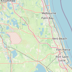


Leaflet | © OpenStreetMap contributors