Latitude and longitude of East Oregon Cattle Company Airport
- Nearby Eagle Point, Oregon, United States
Satellite map of East Oregon Cattle Company Airport
East Oregon Cattle Company Airport (FAA LID: 0OR5) is a private Airport located 3 miles northwest of Eagle Point in Jackson County, Oregon, USA.
Latitude: 42° 30' 7.46" N
Longitude: -122° 51' 10.28" W
Nearest city to this article: Eagle Point, Oregon
Read about East Oregon Cattle Company Airport in the Wikipedia Satellite map of East Oregon Cattle Company Airport in Google Maps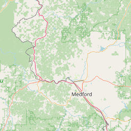


Leaflet | © OpenStreetMap contributors