Latitude and longitude of Savannah River Site
Satellite map of Savannah River Site
The Savannah River Site (SRS) is a nuclear reservation in the United States in the state of South Carolina, located on land in Aiken, Allendale and Barnwell Counties adjacent to the Savannah River, 25 miles (40 km) southeast of Augusta, Georgia. The site was built during the 1950s to refine nuclear materials for deployment in nuclear weapons.
Latitude: 33° 14' 47.18" N
Longitude: -81° 40' 4.44" W
Nearest city to this article: Barnwell, South Carolina
Read about Savannah River Site in the Wikipedia Satellite map of Savannah River Site in Google Maps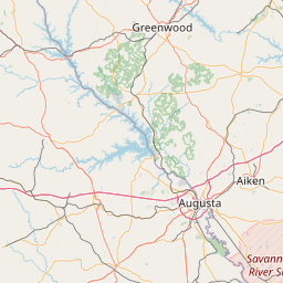


Leaflet | © OpenStreetMap contributors