Latitude and longitude of Illinois Institute of Technology
- Nearby Blue Island, United States
Satellite map of Illinois Institute of Technology
Illinois Institute of Technology, commonly called Illinois Tech or IIT, is a private Ph.D.-granting research university located in Chicago, in the U.S. state of Illinois, with programs in engineering, science, psychology, architecture, business, communications, industrial technology, information technology, design and law.
Latitude: 41° 50' 2.84" N
Longitude: -87° 37' 25.19" W
Nearest city to this article: Chicago
Read about Illinois Institute of Technology in the Wikipedia Satellite map of Illinois Institute of Technology in Google Maps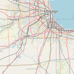


Leaflet | © OpenStreetMap contributors