Latitude and longitude of Astoria–Megler Bridge
- Nearby Warrenton, Oregon, United States
Satellite map of Astoria–Megler Bridge
The Astoria–Megler Bridge is a steel cantilever through truss bridge that spans the Columbia River between Astoria, Oregon and Point Ellice near Megler, Washington, in the United States. Located 14 miles (23 km) from the mouth of the river, the bridge is 4.1 miles (6.6 km) long and was the last completed segment of U.S. Route 101 between Olympia, Washington, and Los Angeles, California.
Latitude: 46° 13' 1.20" N
Longitude: -123° 51' 28.19" W
Nearest city to this article: Astoria, Oregon
Read about Astoria–Megler Bridge in the Wikipedia Satellite map of Astoria–Megler Bridge in Google Maps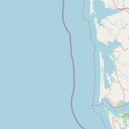


Leaflet | © OpenStreetMap contributors