Latitude and longitude of Lamar, Texas
- Nearby Rockport, Texas, United States
Satellite map of Lamar, Texas
Lamar is a small, unincorporated community and census-designated place (CDP) in Aransas County, Texas, United States, 10 miles (16 km) north of Rockport and 40 miles (64 km) north of Corpus Christi. As of the 2010 census it had a population of 636. The community was named for Mirabeau B.
Latitude: 28° 08' 13.20" N
Longitude: -97° 00' 12.00" W
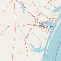


Leaflet | © OpenStreetMap contributors