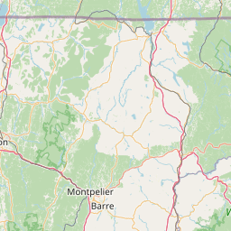
Latitude and longitude of Fort Ethan Allen
- Nearby Burlington, Vermont, United States
Satellite map of Fort Ethan Allen
Fort Ethan Allen was a U.S. army installation in Vermont, named for American Revolutionary War figure Ethan Allen. First serving as a cavalry post in 1894, today it is the center of a designated national historic district straddling the town line between Colchester and Essex.
Latitude: 44° 30' 11.99" N
Longitude: -73° 09' 0.60" W
Nearest city to this article: Winooski, Vermont
Read about Fort Ethan Allen in the Wikipedia Satellite map of Fort Ethan Allen in Google Maps

Leaflet | © OpenStreetMap contributors