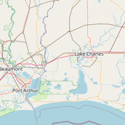
Latitude and longitude of Sam Houston Jones State Park
- Nearby Lake Charles, Louisiana, United States
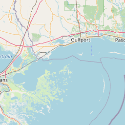
Satellite map of Sam Houston Jones State Park
Sam Houston Jones State Park is a park in near the city of Lake Charles, Calcasieu Parish, in southwestern Louisiana (USA) located at the confluence of the Houston and Calcasieu Rivers and Indian Bayou. It consists of 1,087 acres (440 ha) of woodlands, lakes and rivers. Prominent in the park are many bald cypress trees. Tree-filled lagoons and a mixed pine and hardwood forest combine to create a unique natural environment. The area hosts an abundance of wildlife, including deer, squirrels, bobcats, rabbits, alligators, otters, nutria rats, raccoons, foxes, and diverse birdlife. The park also has a herd of deer kept in a special area of the park.
Latitude: 30° 18' 1.80" N
Longitude: -93° 15' 30.60" W
Nearest city to this article: Moss Bluff
Read about Sam Houston Jones State Park in the Wikipedia Satellite map of Sam Houston Jones State Park in Google Maps