Latitude and longitude of Oceanside Municipal Airport
- Nearby Oceanside, California, United States
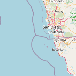
Satellite map of Oceanside Municipal Airport
Oceanside Municipal Airport (IATA: OCN, ICAO: KOKB, FAA LID: OKB) is a public airport located two miles (3 km) northeast of the central business district of Oceanside, a city in San Diego County, California. The airport covers 43 acres (170,000 m2) and has one runway. It is mostly used for general aviation.
Latitude: 33° 13' 3.00" N
Longitude: -117° 21' 2.99" W
Nearest city to this article: Camp Pendleton South
Read about Oceanside Municipal Airport in the Wikipedia Satellite map of Oceanside Municipal Airport in Google Maps


Leaflet | © OpenStreetMap contributors