Latitude and longitude of Dunnellon/Marion County Airport
- Nearby Ocala, United States
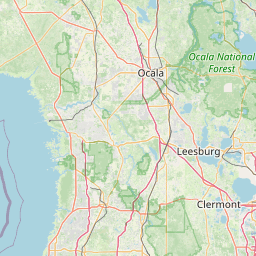
Satellite map of Dunnellon/Marion County Airport
Dunnellon/Marion County Airport and Park of Commerce (FAA LID: X35) is a public use airport located four nautical miles (7 km) east of the central business district of Dunnellon, in Marion County, Florida, United States.
Latitude: 29° 03' 25.20" N
Longitude: -82° 22' 21.59" W


Leaflet | © OpenStreetMap contributors