Latitude and longitude of Trinity Catholic High School (Florida)
- Nearby Ocala, United States
Satellite map of Trinity Catholic High School (Florida)
Trinity Catholic High School is a Roman Catholic college preparatory day school in Ocala, Florida. It is operated by the Congregation of Christian Brothers.
Latitude: 29° 08' 25.80" N
Longitude: -82° 10' 2.40" W
Nearest city to this article: Ocala
Read about Trinity Catholic High School (Florida) in the Wikipedia Satellite map of Trinity Catholic High School (Florida) in Google Maps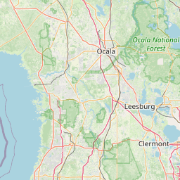


Leaflet | © OpenStreetMap contributors