Latitude and longitude of Stanton Street Bridge
- Nearby Canutillo, United States
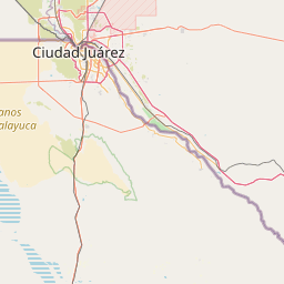
Satellite map of Stanton Street Bridge
The Good Neighbor International Bridge, commonly known as the Stanton Street Bridge, is an international bridge connecting the United States-Mexico border cities of El Paso, Texas, and Ciudad Juárez, Chihuahua across the Rio Grande (Río Bravo). The bridge is also known as "Friendship Bridge", "Puente Río Bravo" and "Puente Ciudad Juárez-Stanton El Paso". The Good Neighbor International Bridge is a five lane bridge with 4 lanes for south bound traffic and one for north bound traffic. The bridge was constructed in 1967 and is 880 feet (270 m) long. The U.S.
Latitude: 31° 44' 31.83" N
Longitude: -106° 28' 34.66" W
Nearest city to this article: Ciudad Juárez
Read about Stanton Street Bridge in the Wikipedia Satellite map of Stanton Street Bridge in Google Maps

Leaflet | © OpenStreetMap contributors