Latitude and longitude of Lake Success (California)
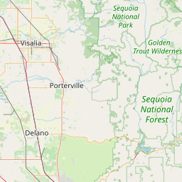
- Nearby Porterville, California, United States
Satellite map of Lake Success (California)
Lake Success is a lake near Porterville, California on the Tule River at (36.06°N 118.92°W). It is formed by Success Dam and has a capacity of 82,000 acre feet (101,000,000 m3). The 156 feet (48 m) tall earth dam is owned and operated by the U.S. Army Corps of Engineers.
Latitude: 36° 03' 37.82" N
Longitude: -118° 55' 9.35" W
Nearest city to this article: East Porterville
Read about Lake Success (California) in the Wikipedia Satellite map of Lake Success (California) in Google Maps

Leaflet | © OpenStreetMap contributors