Latitude and longitude of Mt. Carmel High School (San Diego, California)
- Nearby Fairbanks Ranch, United States
Satellite map of Mt. Carmel High School (San Diego, California)
Mt. Carmel High School (MCHS), a California Distinguished High School in 2005, is located in Rancho Peñasquitos, a community of San Diego, California, United States. The school belongs to the Poway Unified School District and its mascot is the Sundevil.
Latitude: 32° 57' 59.99" N
Longitude: -117° 07' 9.60" W
Nearest city to this article: Poway
Read about Mt. Carmel High School (San Diego, California) in the Wikipedia Satellite map of Mt. Carmel High School (San Diego, California) in Google Maps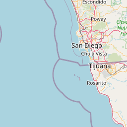


Leaflet | © OpenStreetMap contributors