Latitude and longitude of Alta Vista, San Diego
- Nearby Encinitas, United States
Satellite map of Alta Vista, San Diego
Alta Vista is a small neighborhood in Southeastern San Diego, and is bordered by National City to the East, Bay Terraces to the West, Encanto and Valencia Park to the North.
Latitude: 32° 50' 14.39" N
Longitude: -117° 16' 22.20" W
Nearest city to this article: La Jolla
Read about Alta Vista, San Diego in the Wikipedia Satellite map of Alta Vista, San Diego in Google Maps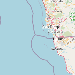


Leaflet | © OpenStreetMap contributors