Latitude and longitude of Whatcom Falls Park
- Nearby Bellingham, United States
Satellite map of Whatcom Falls Park
Whatcom Falls Park is a 241-acre (0.98 km2) park in Bellingham, Washington, USA. The falls are on Whatcom Creek, which leads from Lake Whatcom to Bellingham Bay.
Latitude: 48° 45' 7.56" N
Longitude: -122° 25' 59.16" W
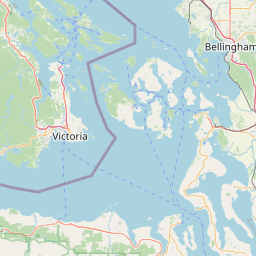

Leaflet | © OpenStreetMap contributors