Latitude and longitude of Lea County Regional Airport
- Nearby Hobbs, New Mexico, United States
Satellite map of Lea County Regional Airport
Lea County Regional Airport (IATA: HOB, ICAO: KHOB) (Lea County-Hobbs Airport) is four miles (6.4 km) west of Hobbs, in Lea County, New Mexico. The airport covers 898 acres (363 ha) and has three runways.
Latitude: 32° 41' 8.99" N
Longitude: -103° 13' 0.60" W
Nearest city to this article: Hobbs, New Mexico
Read about Lea County Regional Airport in the Wikipedia Satellite map of Lea County Regional Airport in Google Maps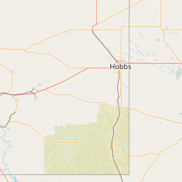

Leaflet | © OpenStreetMap contributors