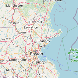
Latitude and longitude of Massachusetts Institute of Technology
- Nearby Chelsea, Massachusetts, United States
Satellite map of Massachusetts Institute of Technology
The Massachusetts Institute of Technology (MIT) is a private research university in Cambridge, Massachusetts. Founded in 1861 in response to the increasing industrialization of the United States, MIT adopted a European polytechnic university model and stressed laboratory instruction in applied science and engineering. Researchers worked on computers, radar, and inertial guidance during World War II and the Cold War. Post-war defense research contributed to the rapid expansion of the faculty and campus under James Killian.
Latitude: 42° 21' 35.35" N
Longitude: -71° 05' 31.60" W
Nearest city to this article: Boston
Read about Massachusetts Institute of Technology in the Wikipedia Satellite map of Massachusetts Institute of Technology in Google Maps


Leaflet | © OpenStreetMap contributors