Latitude and longitude of Southern California Logistics Airport
- Nearby Hesperia, California, United States
Satellite map of Southern California Logistics Airport
Southern California Logistics Airport (IATA: VCV, ICAO: KVCV), also known as Victorville Airport, is a public airport located in the city of Victorville in San Bernardino County, California approximately 20 mi (32 km) north of San Bernardino.
Latitude: 34° 35' 30.59" N
Longitude: -117° 22' 35.39" W
Nearest city to this article: Adelanto
Read about Southern California Logistics Airport in the Wikipedia Satellite map of Southern California Logistics Airport in Google Maps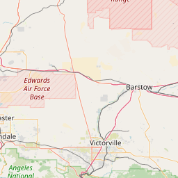

Leaflet | © OpenStreetMap contributors