Latitude and longitude of Mima mounds
- Nearby Tumwater, United States
Satellite map of Mima mounds
Mima mounds /ˈmaɪmə/ are low, flattened, circular to oval, domelike, natural mounds that are composed of loose, unstratified, often gravelly sediment that is an overthickened A Horizon. These mounds range in diameter from 3 to more than 50 m; in height 30 cm to greater than 2 m; and in density from several to greater than 50 mounds per hectare, at times forming conspicuous natural patterns. Mima mounds can be seen at the Mima Mounds Natural Area Preserve in Washington State.
Latitude: 46° 53' 54.82" N
Longitude: -123° 03' 1.73" W
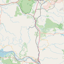


Leaflet | © OpenStreetMap contributors