Latitude and longitude of St. Thomas Aquinas High School (Dover, New Hampshire)
Satellite map of St. Thomas Aquinas High School (Dover, New Hampshire)
St. Thomas Aquinas High School is a coeducational Catholic high school in Dover, New Hampshire, in the Roman Catholic Diocese of Manchester.
Latitude: 43° 09' 3.00" N
Longitude: -70° 50' 16.79" W
Nearest city to this article: Eliot, Maine
Read about St. Thomas Aquinas High School (Dover, New Hampshire) in the Wikipedia Satellite map of St. Thomas Aquinas High School (Dover, New Hampshire) in Google Maps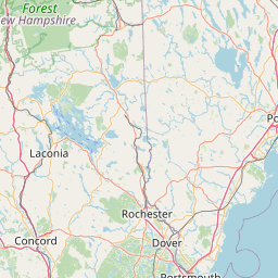


Leaflet | © OpenStreetMap contributors