Latitude and longitude of Temple of Israel (Wilmington, North Carolina)
- Nearby Carolina Beach, United States
Satellite map of Temple of Israel (Wilmington, North Carolina)
The Temple of Israel is a Jewish house of prayer located on the corner of Fourth and Market Streets in Wilmington, North Carolina, United States. Built in 1876, the Temple of Israel is the oldest synagogue in North Carolina and one of the earliest Reform synagogues in the American South.
Latitude: 34° 14' 7.66" N
Longitude: -77° 56' 39.84" W
Nearest city to this article: Wilmington, North Carolina
Read about Temple of Israel (Wilmington, North Carolina) in the Wikipedia Satellite map of Temple of Israel (Wilmington, North Carolina) in Google Maps
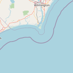


Leaflet | © OpenStreetMap contributors