Satellite map of Rosny, Tasmania
Rosny is a suburb of the City of Clarence, part of the greater Hobart area, Tasmania, Australia. It is located on the eastern shore of the Derwent River, between the suburbs of Montagu Bay and Rosny Park, approximately 4 kilometres from Hobart's centre.
Latitude: -42° 52' 14.39" S
Longitude: 147° 21' 10.19" E
Nearest city to this article: Bellerive
Read about Rosny, Tasmania in the Wikipedia Satellite map of Rosny, Tasmania in Google Maps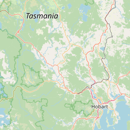


Leaflet | © OpenStreetMap contributors